Difference between revisions of "Add Layer"
(→File:Raster.png Coverage (Raster)) |
(→File:shapfile_icon_70.png Shapefile (polygon/point)) |
||
| Line 1: | Line 1: | ||
| − | The <b>Add</b> button opens the Upload | + | The <b>Add</b> button opens the Upload data screen (Fig. 1). You may upload a [[Add Layer#Table_.28point.29|<b>Table (point)</b>]], [[Add_Layer#Coverage_.28raster.29|<b>Coverage (raster)</b>]] or [[Add Layer#Shapefile_.28polygon.2Fpoint.29|<b>Shapefile (polygon/point)</b>]] file. Click <b>Choose File</b> to browse to your file. You must then select a <b>Category</b> (used for classification in the layer list) and may add a <b>Description</b> of your dataset. Click <b>Upload</b> when you are finished. |
| − | [[File: | + | [[File:new_add_layer_60.png|alt=Data Upload|Data Upload|frame<b>|Figure 1:</b> Upload data screen ]] |
| − | ==[[File: | + | <br clear=all> |
| + | |||
| + | ==[[File:table_icon_70.png]] Table (point)== | ||
Make sure that your table meets the following standards: | Make sure that your table meets the following standards: | ||
| − | <b>Format</b>: Only | + | <b>Format</b>: Only Excel files (*.xlsx) and semicolon-delimited files (*.csv) are valid. The file name may not contain any blank spaces. |
| − | <b>Headers</b>: The first line of the table the | + | <b>Headers</b>: The first line of the table contains the names of each data column. These names must not contain any punctuation or special characters, such as '?', '/' or 'ü' or any blank spaces and may not begin with a number. Column names that are reserved and <b>may not</b> be used are: 'ID', 'long', 'time', 'as'. |
| − | <b>Required columns</b>: | + | <b>Required columns</b>: Latitude and longitude columns are required. |
| − | * | + | * Acceptable latitude column names: Latitude, Lat, Y, North, Northing |
| − | * | + | * Acceptable longitude column names: Longitude, Lon, X, East, Easting |
| − | + | Make sure that the first line of data, i.e. the second line of your table, contains numerical values in every column and has no empty cells. Otherwise, the entire column with the blank cell will be treated as a string and cannot be used as numerical data. Likewise, if your numerical data contain a combination of float (decimal) and integer (whole number) data, make sure that a decimal value occupies the first line of data. | |
| − | |||
| − | Make sure that the first line of data, i.e. the second line of your table, contains numerical values | ||
'''Example Table''' (VAR1 and VAR2 are arbitrary variables) | '''Example Table''' (VAR1 and VAR2 are arbitrary variables) | ||
| Line 36: | Line 36: | ||
|} | |} | ||
| − | ==[[File: | + | ==[[File:coverage_icon_70.png]] Coverage (raster)== |
<b>Format</b>: *.tif | <b>Format</b>: *.tif | ||
| Line 44: | Line 44: | ||
<b>Size</b>: max. 150 MB | <b>Size</b>: max. 150 MB | ||
| − | <b>Projection</b>: The only | + | <b>Projection</b>: The only supported projection is [[Add Layer#Valid projection|<b>WGS84</b>]] |
| + | |||
| + | ==[[File:shapfile_icon_70.png]] Shapefile (polygon/point)== | ||
| − | + | <b>Format:</b> Only a compressed .zip file with all necessary files is valid (Fig. 2). | |
| − | <b> | + | <b>Contents:</b> The .zip file must contain a *.dbf, *.prj, *.shp, *.shx file each and can additionally contain a *.sbx and *.sbn file. There may not be any sub-folders within the .zip file. |
| − | <b> | + | <b>Projection:</b> The only supported projection is [[Add Layer#Valid projection|<b>WGS84</b>]]. |
| − | + | [[File:ShapeFileContents_fixed.JPG|left|alt=Contents of zip file|Contents of zip file|<b>Figure 2:</b> Contents of zip file ]] | |
| − | + | <br clear=all> | |
==Valid projection== | ==Valid projection== | ||
| − | <b>Geographic | + | <b>Geographic coordinate system</b>: GCS_WGS_1984 |
| − | <b>Datum</b> | + | <b>Datum:</b> D_WGS_1984 |
| − | <b>Prime Meridian</b> | + | <b>Prime Meridian:</b> Greenwich |
| − | <b>Angular Unit</b> | + | <b>Angular Unit:</b> Degree |
| − | <b>EPSG</b> | + | <b>EPSG:</b> 4326 |
| − | For more information | + | For more information, see [http://spatialreference.org/ref/epsg/wgs-84/ WGS84] |
Latest revision as of 14:46, 8 August 2018
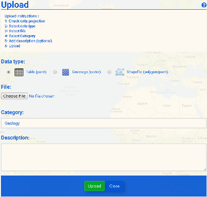
The Add button opens the Upload data screen (Fig. 1). You may upload a Table (point), Coverage (raster) or Shapefile (polygon/point) file. Click Choose File to browse to your file. You must then select a Category (used for classification in the layer list) and may add a Description of your dataset. Click Upload when you are finished.
 Table (point)
Make sure that your table meets the following standards:
Format: Only Excel files (*.xlsx) and semicolon-delimited files (*.csv) are valid. The file name may not contain any blank spaces.
Headers: The first line of the table contains the names of each data column. These names must not contain any punctuation or special characters, such as '?', '/' or 'ü' or any blank spaces and may not begin with a number. Column names that are reserved and may not be used are: 'ID', 'long', 'time', 'as'.
Required columns: Latitude and longitude columns are required.
- Acceptable latitude column names: Latitude, Lat, Y, North, Northing
- Acceptable longitude column names: Longitude, Lon, X, East, Easting
Make sure that the first line of data, i.e. the second line of your table, contains numerical values in every column and has no empty cells. Otherwise, the entire column with the blank cell will be treated as a string and cannot be used as numerical data. Likewise, if your numerical data contain a combination of float (decimal) and integer (whole number) data, make sure that a decimal value occupies the first line of data.
Example Table (VAR1 and VAR2 are arbitrary variables)
| Index | Lat | Lon | VAR1 | VAR2 |
|---|---|---|---|---|
| 1 | 28.4 | 87.6 | 1 | 2 |
| 2 | 27.9 | 87.5 | 2 | 0 |
 Coverage (raster)
Format: *.tif
Bands: Only single-band rasters are supported.
Size: max. 150 MB
Projection: The only supported projection is WGS84
 Shapefile (polygon/point)
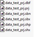
Format: Only a compressed .zip file with all necessary files is valid (Fig. 2).
Contents: The .zip file must contain a *.dbf, *.prj, *.shp, *.shx file each and can additionally contain a *.sbx and *.sbn file. There may not be any sub-folders within the .zip file.
Projection: The only supported projection is WGS84.
Valid projection
Geographic coordinate system: GCS_WGS_1984
Datum: D_WGS_1984
Prime Meridian: Greenwich
Angular Unit: Degree
EPSG: 4326
For more information, see WGS84

